Wednesday, 17 Jul 2024
MSDI : “We Work Without Borders”
Surabaya, 17 July 2024 - MSDI is a company that focuses on providing UAV solutions for industry and topography in Indonesia. MSDI provides Drone services throughout Indonesia. MSDI offers high-tech drone mapping services with LiDAR technology. MSDI are licensed as European & Indonesian Drone Pilot Certificate operators, qualifying to fly in Europe, Indonesia, and many other countries.
MSDI are passionate about drones! As lovers of drones and new technology, MSDI have acquired years of experience since 2015. The MSDI brand is born from the company PT. Bali Drone Production, specializing in videography and photography production services. MSDI uses RTK technology to synchronize drones, providing extremely precise planning. The accuracy offered varies from 3 to 5 cm in photogrammetry and between 0.5 and 2.5 cm for LiDAR. 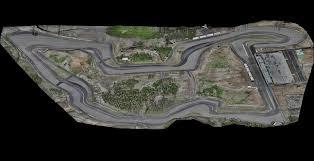
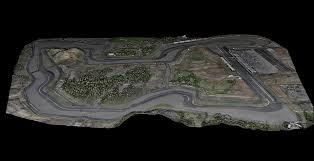
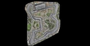
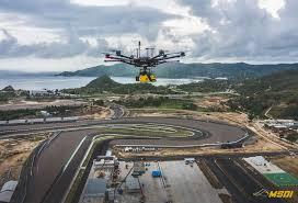
LiDAR Mapping System in Intenational Circuit Mandalika
Light Detection and Ranging (LIDAR) is an assembly of different modules to emit light in the form of a laser and measure its variations when it encounters an obstacle. Variations will be generated and transcribed into points representing points that could become a 3D representation of the environment. From the point cloud, it can extract other data, such as contour lines, and realize an orthomosaic plan from the captured photos. The data is integrated into professional software such as GIS or AutoCAD. MSDI provides UAV solutions for drone mapping, high-end LIDAR technology, and others.
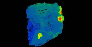
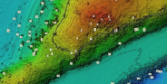
Contour Lines and Digital Terrain
MSDI helped the Antasena ITS Team to obtain heat map terrain data and terrain mapping on the International Mandalika Circuit. Support from MSDI is also the key to this team's success. The drones they provide are equipped with advanced technology that allows detailed mapping of the terrain around Mandalika. This information will help the Antasena team optimize the performance of their modules during the competition, taking into account variables such as wind direction and geographical conditions.
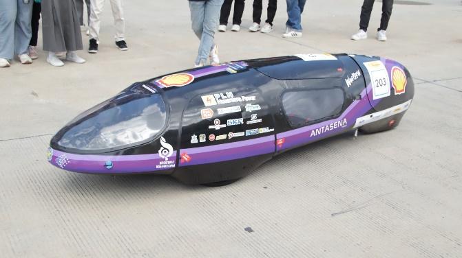
Antasena Falcon
Antasena ITS team once again showed its spirit of innovation by participating in the Shell Eco Marathon 2024. Carrying a new car “Falcon”, Antasena ITS team continues to strive to push the boundaries of efficiency and sustainability in the automotive world, especially in the hydrogen category. Technological support from MSDI Drone Indonesia has made a big contribution to our journey.
With detailed and accurate mapping data, the team can make the necessary adjustments to improve the car's efficiency and performance. Technology support from MSDI gives the Antasena ITS Team a competitive advantage and a strong foundation to continue to innovate in future competitions. Support from MSDI to Antasena ITS Team has made a significant contribution, enabling the team to carry out in-depth mapping and analysis. This is not only helps in competition preparation, but also provides valuable learning for future improvement.
Thank you to MSDI for being able to support Antasena ITS Team in its efforts to create sustainable innovation in the automotive sector, especially in hydrogen category. We are confident that our passion and dedication will continue to bring the Antasena Team to success in the future.